Tuesday, October 25, 2011
Thursday, August 18, 2011
Wrapping up Alaska 2011
I can't say we dreamed and thought about this summer's trip all that often over the years. But, we always knew it would happen. Fuel prices tempted us to put the trip off this year. Thankfully, we still have the big three: health, time and each other. So we loaded up and took off.
We left on July 6th driving a 2001 Ford ¾ ton diesel pickup with 182,099 miles on the speedometer. On the back of the pickup we carried a 2005 850SC NorthStar popup pickup camper. Obviously, we saw no need to have new equipment.
We returned on August 17th after 39 days. The ending mileage was 192,102. Here is the summary.
We drove 10,002 miles, used 666.725 gallons of fuel, averaging 15.001 miles per gallon and $4.522 per gallon for diesel, for a total of $3015.00. (I converted all of Canada's metric figures to keep it equal.) I guess the reason I found these figures interesting is because I saved $3,000 for the trip but with higher fuel prices, I figured that amount would probably only pay for the fuel. Right on there!
We decided to convert $1,500 to Canadian money just to have the cash available. The rate was $1.06 American for each $1 Canadian. That amount of money paid for all fuel, camping fees and Canadian groceries except for two credit card charged fuel fills. At the border, coming home, we had enough change to buy a bottle of Crown Royal at the duty free shop. (It was a small bottle:)
I did not keep accurate records on other expenditures. However, we roughly figured how many nights we paid for camp spots, restaurant meals and misc expenses and $1,000 would almost cover it. (I don't count groceries because we have to eat at home).
So, bottom line, in this summer's economy, it took close to $4,000 for this trip.
Another expense I am not counting toward the total is the cost of shipping our salmon home. Chip took care of all of that for us and we are paying him by the pound. It cost about around $10.50 per pound. That sounds high, but it is our salmon, the fish we actually caught. So many companies put the fish in bulk processing. I appreciate knowing how they were handled. Frozen wild-caught sockeye salmon in stores cost $6 to $7 a pound so it isn't too bad
.
Finally, we want to thank all those who looked after our place while we were gone. Family: Marc and Kim. Friends: Tom and Christy, Mark and Brenna, Mark and Kitty and others who kept a watchful eye on who came in and out of the driveway.
Hopefully, this information will encourage others thinking about a similar trip. There are other options, cruises, fly up and rent an RV or car. Still, there wasn't any part of this trip I would leave out. The road trip across Canada is beautiful. So, if you have time, do it all. Or if not, just do as much as you can. It's worth every cent you will spend.
Thank you Carol Lindahl for making this map for us. Amazing!

Wednesday, August 17, 2011
Laramie Wyoming to Home Sunday, August 14 720 miles
I’ve received emails and calls wondering if we were home. Sorry I haven’t posted as promised.
Sunday evening, actually Monday morning, we rolled in having traveled about 100 more miles than we should have. We were just too close. It was 1:00 am when we turned off the truck. I think the only other times we gave it a rest were when we fueled up.
We finally unloaded the camper today. It is clean and empty. We accumulated more than I thought along the way. I tried to keep the souvenirs to a minimum because of space, but had to get a few things. Travel brochures ended up being the biggest collection. There is so much information that I need to read over to make sure I know where each picture was taken.
Tomorrow I plan to get the figures together and post. What we’ve looked at so far is very interesting—at least we think so.
Saturday, August 13, 2011
Grand Teton National Park on to Laramie Saturday, August 13 465 miles
What a grand surprise this morning. It wasn’t 10 miles from our campground that we saw one of my favorite sights--

And the sights just got better, which is good after a late start. From the beginning of this trip, we I decided to use the camper as intended, including real dishes, not paper, and showering right here in the camper. I strongly felt living normally would help make us feel this little space is our home. I believe it worked. Except…we do not have a water monitor built in and have to visually check the water level. Which we did a good job of until late last night. So, before we could start our day, we had to find potable water to get us home. Our habit of “camping light” makes it necessary to “ask local” which nearly always results in friendly helpfulness but a little extra time.
Anyway, back to the “Grand” Tetons. I’ll have to be honest, we did see many similar vistas in Alaska. But there is something about Jenny Lake right there by those huge mountains that is still majestic. There are Trumpeter Swans that make their home there and we found them. Unfortunately, my picture did not turn out. However, while we were down a side road trying to get a swan picture, Dan spotted this

If he would have had his leather gloves, he would have pulled the musk thistle out. Probably most would think he was pulling the beautiful wildflowers rather than the noxious, invasive weed it is.
This is the classic view of the mountains. People were waiting in line for this position.

We’re sitting in the parking lot of Walmart in Laramie, Wyoming. I think we’ll rock to sleep tonight with the wind, but we’re not complaining because the price is right. About eight other RVs here agree.
Just outside of Rawlins, Wyoming we headed into this view. It struck me at the time that all our family and friends, wherever they live, are seeing the same full moon and appreciating the Man’s big bright face. Sometimes that’s the best scenery—something that everyone can see for themselves and enjoy.

I want to take this opportunity to thank each of you for stopping by to check up on our trip. We’ll be home late tomorrow night, we’re too close to stop again. It will take a day or so to total everything up so check back in then for average fuel mpg, total miles driven, and, yes, I’ll share how much this all cost.
Yellowstone National Park Friday, August 12
There is nothing like Yellowstone. Looking up are mountains both rugged and pine-covered. Amazingly pine covered after the 1988 fire destroyed so many. Looking down, most of the time, are streams slowly meandering in meadows and against the foothills. Then, every so often are hot pools that smell like a high school chemistry class.

Or bubbling pools that look like chicken gravy cooking.

Or this beautiful Old Faithful.

We arrived at Yellowstone from just south of Helena around 1:30pm. We camped in the Lewis Lake campground which is at the very end of the park last night. Needless to say, we did not see or do everything available in Yellowstone. For one thing, it is still the tourist season and we are not fond of crowds. But we enjoyed the visit, put our feet in a stream, walked the boardwalk to see the Paint Pots and waited 45 minutes on Old Faithful. There were license plates from all over the US and heard foreign languages. This is America’s Park. And, very kid friendly, so lots of young families. A fun, short visit.
Tomorrow, Tetons and definitely homeward bound.
Friday, August 12, 2011
Another August 11 entry
I was so excited to post about our arrival into the US that I forgot a couple interesting notes about southern Canada.
The area south of Calgary to the border is a prosperous Canadian farming area. We saw this striking field of blue so turned down a gravel side road to visit with someone in a pickup parked down the way. He was taking pictures as well and was knowledgable about the region. He told us the lovely field stretched out before us is flax. Of course, its seeds will be used is various healthy ways as the oil. We were correct in assuming the yellow blooming fields are canola—and they call it that, not rape. He also told us the region grows all types of wheat, spring, hard winter wheat and white wheat. They were just beginning to harvest. Crews were moving into the big fields.
Here is the flax field
 Also, somewhere after the casino camping spot, I took a picture of this railroad bridge. I didn’t note where but it is so impressive that I’m putting it in here and hoping Carol can locate it for me:)

Back in the Good Ole’ USA Thursday, August 11 491 miles
We crossed the border around 1:00 today. There is a big flag up on a hill in the town of Sweetgrass. I am sure I’m not the only traveler who got a lump in the throat when it comes into view. Not that Canadians aren’t the nicest people, who are proud of their country and show it in how they take care of it. But, there are some things that are just America.
This sign was at the first rest stop we came to…. We’re home.

No signage in Canada made me laugh like this one in Great Falls.

Speaking of Great Falls, we spent more time there today than intended.
First, I will say we’ve been extremely fortunate not to have any mechanical failures. We still haven’t. What we did find this morning was a cut on the sidewall of one of our back tires. It didn’t look too serious, so we headed for Great Falls because we knew they had a Walmart to fulfill our road hazard policy.
No problem with getting a new tire, but we had to wait at least two hours to get it mounted. There was only one man working, and he was very nice, but he was struggling with being behind. We were finally back on the road by 8:30 pm. We decided to drive a bit & stay at a rest stop. We are at a rest stop just beyond Helena as I write. We probably should have just stayed in the Walmart parking lot because we drove by some pretty scenery in the dark. The Missouri River runs through a canyon south of Great Falls. The big moon did help, though.
Tomorrow, hopefully Yellowstone.
Thursday, August 11, 2011
Somewhere between Banff and Calgary August 10 578 miles
For those who are wondering, the train didn’t turn out to be a factor last night. Either that or I went to sleep and heard nothing.
We got an early start this morning and moved right along all day. As it turns out, the closest route was for us to go back down through the Columbian Ice Fields. It was good to see it going the other direction. Actually, I would recommend traveling north to south. Until it started raining, the colors were vibrant. Everyone should see this park.
We were going to stay at Lake Louise again, but the campground was full so on to a Provincial Park we saw on the map outside of Banff. Also full. So, we are parked in a casino parking lot. Works for us.
We will be through Canada by noon tomorrow. I will then have internet (Autonet if you want to Google it). and phone service back. We are going to Yellowstone on the way home. Very excited about the stop.
Cassiar Highway – Stewart/Hyder – August 9 521 miles
I forgot to mention in my last post about Jade City located along the Cassiar Hwy. Just the name suggests “tourist trap” but it’s a “must see” stop in the Milepost. Anyway, I had to check out the jade.
We learned there are several jade mines in the Cassiar mountain area that, altogether account for 90 percent of the world’s jade supply. The store had saws set up with slices of the jade rock. It was all very interesting. Of course, there were endless jade articles for sale. After more than a little prodding, I found out that the store can’t get local carvers to make the jade pieces so they have to send their jade off to China. I was pretty sure that was the case just by the amount of articles for sale. Still, the really nice lady assured me all items were made with their jade so I ended up with tiny butterfly earrings.
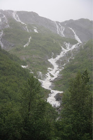
Not far from our overnight stop last night, is the turnoff to Steward/Hyder. The route is laced with glaciers and waterfalls. I don’t even have to say beautiful, right? Several of the glaciers were almost to the road. The deep canyon and fast flowing river along part of the route reminded me of Colorado.
Stewart is at the head of the Portland Canal on the British Columbia/Alaska border. The population of Stewart is 699 and 100 for Hyder. The Canal is a narrow saltwater fjord about 90 miles long and is the natural boundary between Alaska and Canada. It appears Stewart has a logging operation there.
 Hyder is two miles beyond Stewart and it is hard to figure out what the 100 residents do for a living. There are several souvenir stores, and, believe it or not, a post office. But there are dirt streets and lots of run down buildings.


There is one very exciting thing to do in Hyder, though. That is drive 3 miles out of town on a rough, gravel road to the Fish Creek Wildlife Viewing Area. It’s in the Tongass National Park operated by the US Forest Service. It is awesome. There is a viewing platform that goes out over Fish Creek where, today anyway, chum and pink salmon were making their spawning run up the river. As we watched the fish, here came a grizzly and her cub down the river to fish. They spent at least 15 minutes right in front of us.


So, here we are at a boat dock parking area at Frasier Lake on the Yellowhead Hwy. We took the first place we could find because at 10:00 pm everything was closed. So far four trains have gone by within 50 yards of our parking place, each one with three whistles. Serves us right for waiting so long to find a place.
Tomorrow it will be Prince George and it is there that we will have to make a decision on what route to enter the US. Right now we are thinking it will be at the Oregon border, through Idaho and down to Yellowstone. It’s still in negotiations, however.
Tuesday, August 9, 2011
Skagway to Forest Service Road on Cassier Hwy South August 8, 506 miles
The Cassier Hwy is an alternate route to the Alaska Hwy, following a more westerly route. It would be hard to chose which is more beautiful. Cassier follows one valley, river and mountain range after another. The road conditions are about the same. Definitely, anyone driving both ways to Alaska should take both.
It was along the Cassier that we spotted these swans that were close enough to get a good picture. I have been intrigued with the beautiful birds. They are common in Canada and Alaska, but difficult to get a good close picture. So, I am posting two pictures of this graceful couple.


It was approaching 8:30 pm last night and we still hadn’t found just the right place to stop for the night. I spotted a sign, “Forest Service Road.” It was just a short distance down off the highway when we pulled in by a little pond, so quiet that it almost was spooky. Here is the view out of our “bedroom” window.

Tomorrow, the most southern tip of Alaska—Hyder.
Whitehorse to Skagway August 7
The drive into Skagway from Whitehorse is 110 miles. I should say 110 miles of the most unusual beauty we’ve seen so far.
This route is called the Klondike Highway. The Klondike Hwy is the route prospectors took to get to the newly discovered gold at Dawson City. The road as it is now was not completed until 1976. Especially as the road nears the coast and the city of Skagway, it drops down to sea level from above the tree line. The road comes down through a notch of mountains laced with long waterfalls and running water and small natural ponds. The literature calls it “moonscape” which is a good description of an area of more recently glaciated rocks.
This picture is a suspension bridge which seemed to hang on the side of the mountain.
 The first impression of Skagway is “crowded tourist stop.” There were two cruise ships in the harbor when we arrived so the streets were crowded with shoppers. The stores were quaint and colorful, though. And, if I were a shopper, I might have enjoyed browsing.

We parked on a side street, took off our bikes and started riding. We visited the Gold Rush Cemetery, the harbor to watch the harbor seals trying to catch the salmon that were trying to climb the fish ladder. The streams above were full of the determined salmon as well. Since it was Sunday, we ate a fresh fish meal at the local bar.
As 5:30 approached, and we were riding the back streets toward our truck, it struck me this town is like any other small town. Building things, tending flowers and shopping for groceries. I definitely left with a better feeling than when I arrived.
Another must visit in Alaska.
As I write this, I hear what sounds like ocean waves, but it is a huge lake. We asked the border petrol officer if we might camp hear the area nearby. He directed us here. It is no fee, unattended. I feel we are definitely in the wild.

Tomorrow, it’s the Cassiar Highway.
Sunday, August 7, 2011
Delta Junction Alaska to Whitehorse Yukon Saturday August 6 418 miles
We have not hooked up to electricity since we left cousin Cindy's home in Montana. Our stay in Canada and Alaska has been totally dry camping meaning park and sleep mostly in State Parks. The camp sites with electrical hookups were not always in scenic locations and were more expensive (State parks were $12 average) The only challenge has been to keep all electronics charged and and make sure the propane is full. All worked out until this morning. The propane ran out just as the coffee was done perking (thank goodness, the coffee was done). Our backup worked, kept the refrigerator cold, and we made it to the exchange place here in Whitehorse in time.
I had a camp spot picked out on the south side of Whitehorse, but we need a few other supples and Walmart was closed. When we saw the parking lot here at Walmart, we decided to stay. There must be 25 campers. There is even someone tent camping.
After Skagway, we will be at least two days in Canada. I'll write each day and post when we get back into the States.
Even though I haven't replied to your comments, I have appreciated them so much.
Saturday, August 6, 2011
Denali Highway Friday August 6
The highway from Anchorage to Denali National Park is called the Parks Highway. It was built in 1972. Before that time, visitors to what was then called Mt. McKinley National Park traveled on the Danali Highway. It is 134 miles long. Perhaps by design, the state of Alaska has chosen not to improve this road. It is as it was when early travelers made the trip, requiring modern travelers to also move slowly. And, this road should be taken slow. It is unforgettable.
There are valley vistas as far as the eye can see. Small beaver ponds, lakes and clear streams all along the road. Information tells us there are trout in most. The valley floor is framed by mountains, green low, some snow and even a small glacier higher up.
There are informal pull outs, but they were not needed as there was so little traffic. I think we met or came up only four other small RVs and less than ten cars & trucks. We often stopped right on the road.
Here are a few pictures of the journey


We also saw a herd of caribou, eagles, swans, moose, sheep,a wolf and even little bunnies.
As the day began to ebb and the beautiful Denali Park and Road was in our rear view mirror, I spent a little time feeling really down. It was pretty quiet travel. I always do this when I know the end of our trips is in sight. Yes, we are headed south. Currently, we are back on the Alaska Highway. We will be tack in Tok tomorrow—a circle. There will be a couple side trips. Skagway and Prince Rupert but we will be continuing south. I’m feeling better as I write this (11:00 pm Friday Alaska time). We found a pull off along a bubbling stream which is always nice.
Friday, August 5, 2011
Denali National Park – More beautiful than words to describe
We are leaving soon for a cut off across the range that might mean no internet tonight. So, here are a few pictures that in no way can show how beautiful our trip was last night. We did not see Mt. McKinley, but as the literature says, “It is there.” No matter, because the park is pristine and grand. We saw a bear eating a caribou carcass that two wolves had killed. At least one was circling around the bear, the other held back. Wildlife living without human interference.
So, here are my three little pictures to tell a big story
The road:
 The wildlife:

The end:

Thursday, August 4, 2011
Denali National Park. Thursday afternoon
I also booked an evening tour into the park leaving at 5:00pm. It is a 6 hour tour so maybe a sunset.....better yet a glimpse of Mt McKinley
I'll post pictures tomorrow.
Portage Glacier/Whittier then on-the-road to Denali Wednesday
I mentioned we were at Portage Glacier. However, I don't think I mentioned how hard it was raining and blowing. I told myself there is no worry about wind damage in Alaska, but then I thought of the high mountains around me and then I thought flash flood. So, I went to bed, went to sleep and nothing happened. As Dan pointed out this morning, all water drains into the sea from where we were and it's hard to back that one up!
It was still raining just as hard this morning so we decided to move on with our day and not enjoy our coffee as usual. That is how we managed to eat at the Portage Glacier Lodge. What a surprise--another place for my "must go to in Alaska" list. It is just a little dinner, but Dan had a very delicious (I tasted it) Alaskan Skillet with eggs, green onions, boursin cheese, and smoked salmon. I had two huge pancakes. Once again we learned so much by talking to those who live here.
They told us the Portage Glacier valley including Whittier has in the past received more snow than any location in Alaska. Whittier is an old military town where supplies were brought in during WWII. There are tunnels connecting most of the buildings because it gets so much snow in the winter. It is only in the past ten years that the one-way 2 1/4 mile tunnel has been converted to allow cars to alternately go back and forth when there is no train.
The tunnel is impressive. I am glad we experienced it. There was a huge cruise ship in port at Whittier, which was the only excitement there. Definitely, a working port.
As we drove out of the valley, it was still raining heavily. By the time we arrived at Anchorage, there was a sliver of sun here and there. Our friend, Carol from the museum in Soldotna told us to to to the Alaska Native Medical Center for beautiful displays of native art and creativity. She was right. When the Alaska Natives require extended stays at the hospital, they fill their time creatively carving bone, sewing animal fur, beadwork as well as wood and silver carving. It is beautifully displayed and all for sale in the gift shop. So tempting but very expensive.
From there, we are headed to Denali.
Wednesday, August 3, 2011
Alaskans love their coffee


Steward Alaska SeaLife Center, Exit Glacier and Portage Glacier Tues. August 2
The Alaska SeaLife Center is a learning center about all aspects of Alaska waters and wildlife that lives and feeds in, on and around it. Included are displays about their habitat, life cycles, health and history and plans for the future for sea life. Birds and sea creatures are visible from the top as well as under the water.


.
We attended an informative session about Alaska’s early inhabitants by an Alaska Wildlife and Parks ranger. Recent archeological findings have placed early Alutiiq people on the Kenai peninsula living by hunting fur bearing animals 1,400 years ago. In 1741 Russian fur traders forced the native people to hunt for them by removing the strongest men from villages. Within 25 to 30 years after the Russians arrived, 30% died of starvation and soon after another 30% died of small pox. The native people have persevered and there are settlements throughout the Kenai, one of them the Nimlichik village were we dug for clams.
If the weather would have been clear, we might have been able to spot some of the sea creatures in the ocean from a stand complete with a viewing scope. Unfortunately, it was too cloudy. Still, an very well done and educational venue.
As we leave Seward, we drive a short distance into Exit Glacier National Park. There was excitement in doing that with a short drive through fairly swift water over the road. Actually, the road was starting to wash out. I was thankful for our big truck with weight.
The climb to Exit Glacier was wet, but we were able to see the massive ice field up close. This sign says it all. Even with the rain, we could feel the life in the massive glacier.

The mile walk to the glacier.

Up close.

On the way back, we walked down in the valley below the glacier. The run off was too swift otherwise we would have been able to walk to the bottom.
We've seen many glaciers in Alaska and the Columbian Ice Fields in Banff Park, but up close leaves me without words to describe or compare.
Tuesday, August 2, 2011
Sea Otter in Seward Alaska Harbor
http://www.youtube.com/watch?v=sI1Mq-4MevI&feature=youtube_gdata_player
Monday, August 1, 2011
Ninilchik Beach to Seward Beach August 1

It turns out the "Loven' Oven" bakery is owned by the former postmaster of Ninilchik. We had to talk post office for a bit while she wrapped up a huge cinnamon roll and doughnut.
Our route to Seward takes up back through Soldotna then on by the Russian River. The silver salmon had arrived. "Combat" fishermen lined the shore. Often bears join fishermen in catching salmon here. We looked but, unfortunately, that picture did not happen.
We continue up, around and down the other side of the peninsula. It is a scenic drive with streams and low, green mountains. It mist-like rained all day and the low clouds topped most mountains with a beauty all of its own.
Seward is a quaint, little, sea side village. Or, at least it seems that way. No McDonalds or WalMart, just small little shops and restaurants. We spent the rest of the afternoon riding our bikes.

We decided on a camp spot that is right beside the bike trail so we can hop on it and visit the Marine center tomorrow morning. The ocean is right out our other side. I am listening to the tide come in as I write.

There is a sea otter that lives in the small boat cove here. I made a video of him. YouTube hasn't finalized it yet. I'll post it in the morning. Meanwhile, here is a picture of a huge waterfall almost right in town.

Sunday, July 31, 2011
Clams? Yes, but it is work
 It is a big beach and there was plenty of room for everyone. We managed to get about 30 clams. It took a while to develop a technique. First, we looked for a little indention in the sand—a little air hole. We shoveled out sand, hopefully not hitting the clam and breaking it open. (broken clams are very hard to remove all the sand). After digging a shovel full, we dropped down on our knees and started digging with our hands. This picture shows how deep Dan went down to get the clam by the hole.
We quit at 11:00.
 I had Dan’s rain pants with sock feet boots. Dan wore waders. We were a mess top to bottom. Thankfully, the sun was out all afternoon and dried everything out.
Finished batch.
Thanks to friends of Chips at the Soldotna campground and a very helpful camp host here at Niniletuk, we had a whole lot of fun. Speaking of Chip, he and a friend showed up this morning. They definitely found more than we did, but, hey, they had done it before.
Tomorrow, we are headed toward Seward.
Saturday, July 30, 2011
Ninilchik Beach State Campground

I’ve decided clamming is a family and friends time for local residents. There are large groups of families camped together with children running about having a great time.
This little one gets to participate in all the action thanks to big brother.
